
We saw the potential for innovation during the flood events last winter when we released some of our flood data free of charge. Developers came up with a range of solutions to help – from a phone service that connects people with their energy supplier in the event of a power cut to an app that alerts Twitter users to volunteering opportunities in their local area.
We hope that removing cost barriers to our data through Open Data will create more opportunities for developers to create web and mobile applications for businesses and the public to help local communities understand their local environment and better protect themselves from flood risk.
As part of our commitment to make our information easily accessible and available, free of charge and with minimal restriction, I am pleased to say that our Risk of Flooding from Rivers and Sea datasets became Open Data on the 11th December 2014.
Making these datasets Open will allow users access free of charge, even for commercial use; enabling local communities to use our data to better protect themselves from the risk of flooding.
We are releasing three datasets under Open Government Licence and you can access them through data.gov.uk.
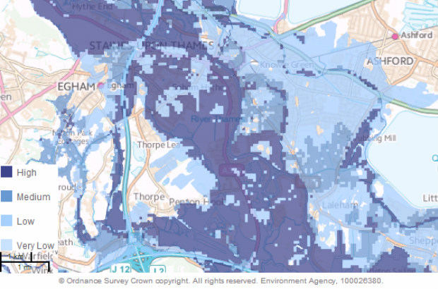
- Risk of Flooding from Rivers and Sea
A map showing the likelihood of flooding from rivers and the sea in England, considering the location, height and condition of 175,000 defences. Results show the annual chance of flooding - Very Low, Low, Medium and High. - Risk of Flooding from Rivers and Sea – Properties in Areas at Risk
A database that uses the Risk of Flooding from Rivers and Sea product with Ordnance Survey data to assign one of the flood likelihood categories to properties simply based on the likelihood of flooding to the area the property is within. - Risk of Flooding from Rivers and Sea – Postcodes in Areas at Risk
A database that uses the Risk of Flooding from Rivers and Sea product with Ordnance Survey data and Royal Mail data to show the number of properties in each postcode area that is in each of the four flood risk categories.
This is part of a bigger commitment for us and we continue working towards making the most of our information by prioritising which of our data to make freely available next.
The second meeting of our Data Advisory Group, chaired by Tom Smith, is on 16th December and I look forward to hearing the group’s view on which of our datasets would be most beneficial to be made openly available.
This is an exciting opportunity for our customers to have a real influence on the data we publish. I would encourage everyone, whether on the group or not, to keep up to date with the progress and we would value all comments and suggestions via our website, twitter feed @dataenvagency and @MirandaK_EA, or through opendata@environment-agency.gov.uk.
15 comments
Comment by Paul posted on
Where can I find out more about the applications developers came up with?
Comment by Environment Agency posted on
Hello Paul
We do not have specific information about these apps as it is open data this can be used by anyone without informing us of its purpose. We are currently looking into using media outlets like Twitter for people to share what they use our data for but again we will only find out further information if anyone responds.
Apologies we cannot be more helpful. Thanks
Comment by M Spiers posted on
Your link to the Open Government Licence (https://enviropedia.eakb.org/index.php/Open_Government_Licence) appears to be broken. I'm guessing that should point to http://www.nationalarchives.gov.uk/doc/open-government-licence/version/3/
Would I also be correct in thinking that the attribution statement should be (c) 2014 and not 2013 as stated on http://data.gov.uk/dataset/risk-of-flooding-from-rivers-and-sea, or is this data already a year old?
Comment by Environment Agency posted on
Hello Mr Spiers thank you for your blog we have asked for advice regarding your enquiry and are waiting for a response. Kind regards Margaret
Comment by Environment Agency posted on
Hello Mr Spiers
The attribution statement dates have now been updated following your feedback.
The archived open government licence is available through your original link, by selecting the hyperlink titled ‘Open Government Licence’
Kind Regards Kerry
Comment by Andy Holmes posted on
Will the surface water flood risk map data be available soon?
Comment by Environment Agency posted on
Dear Andy
Thank you for your enquiry regarding the surface flooding data. Please use the link to data share on this page. There is also information on GOV.UK please use this link to whats in your back yard http://watermaps.environment-agency.gov.uk/wiyby/wiyby.aspx?&topic=ufmfsw. If this still not what you are looking for please email into enquiries@environment-agency.gov.uk with details of an area you are looking at. We will be happy to help you.
Kind regards
Margaret
Comment by M Spiers posted on
Are there any restrictions on using that data commercially?
Comment by daveferguson posted on
Hi, Making these datasets Open will allow users access free of charge, even for commercial use.
Comment by Ricky Lawton posted on
Dear EA,
Does the Environment Agency also publish data around the costs of flooding, composed of:
i) Cost of flood management measures at certain geographical scales (catchment area/GOR etc.)
ii) Costs associated with recorded flood events?
Many thanks,
Ricky
Comment by kathrynbooth posted on
Hi, thank you for your post. We do have some information on Gov.uk here is the link: https://www.gov.uk/government/publications/the-costs-and-impacts-of-the-winter-2013-to-2014-floods if you would like more specific information please email us at: enquiries@environment-agency.gov.uk - we allow 20 working days to process the request. Thank you. Eileen
Comment by Marie Lello posted on
When trying to get home insurance I have been declined as my actual house has been listed as flooded in 2013 & 1958 by the Environment Agency.I have been living in the house since 1998 and it has not been flooded, although the surrounding areas have. How can I get this lifted as it's incorrect about my property?
Comment by kathrynbooth posted on
Hello
We can provide a document which you can give to your insurance company which is called an insurance related request. This is to help them reconsider the situation. It includes information such as:
Whether an area falls within or outside the area at risk of flooding from rivers, the sea and surface water.
Whether there are any defences in the area and the standard of protection that they provide.
How likely flooding is, taking into account any risk management measure such as flood defence barriers in the area.
Whether there are any future plans for flood risk management measures in the area.
If you think this would be beneficial you would need to email:
enquiries@environment-agency.gov.uk
Regards Amy
Comment by Ralph Massie posted on
Where can I get absolute values for the projected sea flooding levels. I appreciate that the flooding level that the risk map is an assumption but it would be nice to have the absolute value in order the determine what flood alleviation measures to put in.
Comment by eileenroffe posted on
Hi Ralph, more tailored information, including detailed flood products for particular sites, is available by sending information requests to enquiries@environment-agency.gov.uk - Joz