
It’s been 2 years since we made our lidar (light detection and ranging) data available to the public, for free, as open data – and the interest in it has been incredible.
In 2016/17, over 500,000 lidar downloads were made from the Survey Open Data portal. That equates to nearly 13 million km2 of data – or the whole of England nearly 100 times.
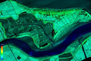
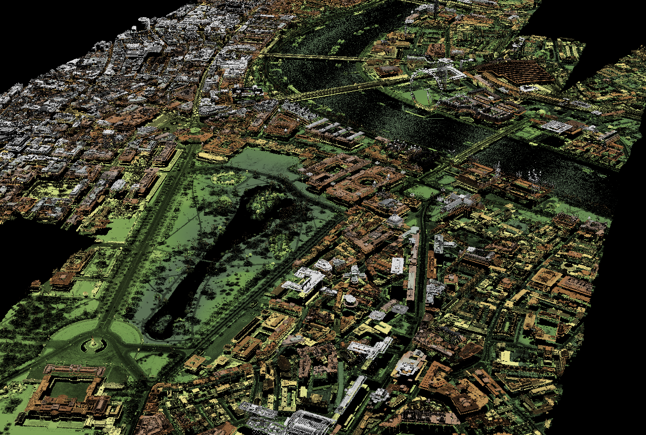
We capture lidar data in England mainly for flood risk mapping, and by 2015 we had covered about 72% of the country. Since then, we’ve surveyed thousands of square kilometres to add another 3% of coverage. Because we gather this data to better understand flood risk, we concentrate on high-risk areas first, and places where there’s the greatest need for up-to-date topographical data.
So although we have been surveying lidar for 19 years, this mapping work has been focused on flood plains, urban areas and the coastal zone. We now need to enhance our understanding of whole catchments to best understand flooding and plan effective defences. Plus, we want to collect data from difficult to reach upland areas, including National Parks, AONBs and SSSIs, environmentally important areas of the country that, until now, have not been fully surveyed.
One of the most common questions we have been asked by data users since we went “open” is, “When are you going to survey the rest of England?”
Well, now we are! Starting this winter flying season, we plan to survey the whole of England at 1m resolution, within the next 3 years.
Our aim is to deliver a full national lidar height dataset by mid-2020. As has always been the case, we will only capture lidar in winter. Flying in winter when the trees are mainly bare means less leaf-cover, so more laser pulses reach the ground. This gives us a high quality Digital Terrain Model (DTM).
There are a number of benefits from the project:
- Our data will be more consistent across the country, particularly for wide scale mapping and modelling.
- Currently 40% of England is either not surveyed, has been surveyed at 2m (meaning it’s not as good quality) or the data is more than 10 years old. For most research and modelling, data needs to be current and at 1m resolution or higher.
- Partners like local authorities, utility companies can use our data for projects to reduce flood risk.
- Having full national coverage will enable us, Defra, NGOs, local authorities and other environmental organisations to carry out conservation projects in many more locations.
- Our new lidar technology enables us to fly at a higher altitude, covering larger swathes of land with each flight.
- Since lidar data was made open, we have received requests from commercial operators looking to develop national products which include lidar data, for example rooftop solar potential maps.
The project will take about 3 years – but fear not. You will not have to wait until then to get your hands on all this new data. We will still release time stamped and point cloud data onto the Survey Open Data platform in our regular half yearly updates.
This Year’s Programme
We have divided the country into 227 survey blocks and aim to capture a third of that each year. As always though, weather conditions and operational issues play a big part in our surveying and can disrupt flying schedules.
If you want to know where we plan to survey during this flying season, check out our survey programme here: http://arcg.is/2iqlqcM.
Find out more
You can find further updates through our Twitter or Facebook or contact us at geomatics_data@environment-agency.gov.uk if you have any feedback or suggestions.
18 comments
Comment by Julian Todd posted on
This is awesome. Is it going to be under the same awkward interface of NE-SW squares within squares within zip files, or will there be an api to make them easier to find?
Someone's going to have to write a lidar downloader plugin for QGIS to automate its access so that every map will have access to it.
https://plugins.qgis.org/plugins/tags/lidar/
Comment by kathrynbooth posted on
Hi Julian,
Please contact the geomatics team direct by e-mail, who will be able to give you more technical information about the project: geomatics_data@environment-agency.gov.uk
Joz
Comment by Mike posted on
Hi Julian
Have you any idea how to open an ASC file to enable me to actually view the Lidar
Comment by Adrian Farnsworth posted on
A simple viewer for UK .asc format lidar is Terrain Bender, 32 or 64 bit.
You will need Java.
Top right of the interface, there is a 'bending' graph . You don't want bending, so pull down all of the nodes to zero, and play...
If you want a guide to using it, I can provide one.
Adrian Farnsworth.
Comment by Julian Pearson posted on
Hi.. I downloaded TB, and the asc files fro the EA.. only to get nothing but a blank screen, no matter what I do on the right hand side... any guidance would be much appreciated please.
Comment by kathrynbooth posted on
Hi, please email: geomatics_data@environment-agency.gov.uk this is the department within the EA responsible. Thank you in advance - Eileen
Comment by JAMES BOOLE posted on
I would greatly appreciate a starter guide to terrain bender.
Comment by Adrian Farnsworth posted on
This is fantastic news, but please don't remove the old data.
"For most research and modelling, data needs to be current and at 1m resolution or higher."
However, from the point of view of archaeology, the older data is often much more valuable than the new, as so much land is being lost to development, particularly locally for us (the Trent valley), where vast gravel extraction is destroying the archaeological landscape.
Comment by Brian Nash posted on
Dear Sir,
Are you the son of our late member Don Farnsworth?
There is a possible project coming up and we 'Derby Heritage Forum" have been asked to contact you by an organiser of same.
Please accept my apologies if this is a misdirected message.
Brian E Nash
Comment by J.Wilson-Bright posted on
In full agreement. Valuable archaeological data is lost daily. Any environmental resource should record changes. Google Earth provide a timeline. Can you manage something similar?
Comment by Dave Giles posted on
How quickly will this data be made available once flown?
Comment by Ford Prefect posted on
Good question. I don't think any of the planned data for winter 2017/18 is available yet, but no doubt it needs processing once the raw data is collected.
Comment by Daniel Kamen posted on
From the EA Facebook pages:
We update the Survey Open Data portal with LIDAR data twice a year (spring and autumn). New data from this programme will start to be available online in the autumn 2018 update (as Tiled LIDAR/time-stamped). The composite is updated once a year, so this new data will be added to the 2018 composite, available early 2019. Data flown in the 2018/19 winter flying season will appear in updates in 2019 and so on.
Comment by Kateřina Thor posted on
Unless they failed to get the survey done as planned - they are behind on 2017/18 flights, so some areas are now 12 months behind schedule
Comment by Anon posted on
Is any of this data available yet?
Comment by Dick posted on
They are hopelessly behind on the planned schedule: 2017 and 2018 they filled in some coastal areas and a large part of the Lake District but everything else is way behind. Moving the data portal to ArcGIS servers has not improved matters; it takes ages to load, if it loads at all.
Comment by kathrynbooth posted on
Hello - the Lidar website is ran by DEFRA the link is here: https://environment.data.gov.uk/searchresults;query=lidar;page=1;pagesize=20;orderby=Relevancy they have a contact page: https://support.environment.data.gov.uk/hc/en-gb - Eileen
Comment by Andy posted on
Is this project ongoing as it seems to have stalled In my area.