
Kate Marks, the Environment Agency’s Deputy Director of Flood Risk Mapping, Modelling and Data explains the background to the most recent changes in how we communicate flood risk.
I love a good map, I even teach map reading in my spare time! For at least the 13 years I’ve been with the Environment Agency, maps have been a good way of communicating flood risk to the public. But we know they don’t work for everyone. Take many of the people I teach, when they start they’d be hard pushed to find their own property or local river on a map, let alone use the map to judge their flood risk. Our research with customers has shown that most people prefer to put in a postcode to select a property of interest and then see simple information about whether the specific address is at risk of flooding and if so what action they can take.
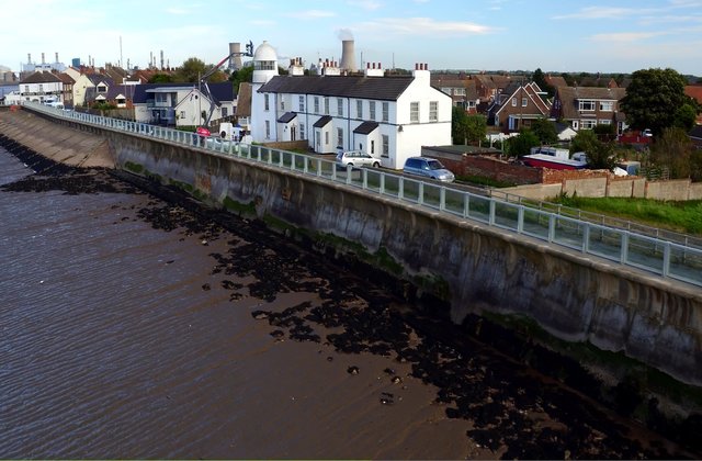
With one in six properties in England at risk of flooding, it is an essential part of the Environment Agency’s role to tell people about flood risk. So we’ve listened, and changed how we present this information to make it easier for people. We have launched a new service that allows people to check the longer term flood risk to a property, alongside existing services that show the immediate flood risk in a location as a result of current weather conditions. This longer term information shows the risk of flooding from rivers, sea, reservoirs and surface water and is primarily used by people considering buying a house, obtaining insurance or wanting to understand if their home or business is at risk.
Another important change we’ve made, based on research and your feedback is to give clearer advice on the action people can take to prepare for flooding. This may include information on whether there is a flood warning service offered in the area, how to make your own property more resilient to flooding and where to get help during a flood.
If you love maps like I do, they are still there, and the information we show on them has also improved. There’s now a simple view of the areas at risk of flooding and a more detailed view you can use to see information such as likely depth and velocity of flood water. The data behind the maps is still shared free of charge, where possible, as Open Data or licensed data to encourage others to include it in their maps and information services. We want to ensure that everyone has access to the best Environment Agency data so that people are better informed about their local environment – one example of how this data is used by others is the environmental search reports which people obtain when buying a house.
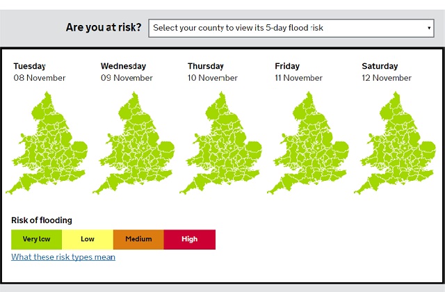
We are continuing to improve our digital services for people to check if they are at immediate risk of flooding, based on feedback from users of the website. We recently added 5-day flood risk information showing the forecast flood risk at a county level across England and Wales. We also have plans to extend our service that shows current river levels to offer river level predictions in the next few hours or days.
This is all part of the important work that we’re doing to improve the way we communicate flood risk as outlined in the National Flood Resilience Review. We’re still listening, learning and evolving the service, so please continue to feedback what else you’d like to see. I won’t be offended if it’s not a map.
13 comments
Comment by George Whitworth posted on
Risk maps are useful, but so also are solution maps. Catchment Process is a path to flood alleviation. Rainfall is a key input to Catchment Process. Please can you make Met-office rain gauge data OPEN (ie as you have done with Lidar relief data). This article relates https://atrepo.com/catchment-process-and-open-data/.
Comment by Jake Arnott posted on
Before I bought my house a year ago, I checked the Environment Agency's maps, and was pleased to find that the are was not at risk from flooding. The latest maps show that it is at high risk from flooding, which has obviously affected my insurance and the value of my house.
Is there any way to find out the data used to make this new assessment, or to ask for the assessment to be reviewed? To my non-expert eye, the risk of flooding seems to be very small, and it seems strange that the agency can change its mind so dramatically without informing those affected, or giving them an opportunity to challenge the findings
Comment by Anon posted on
I agree, exactly the same thing has happened to us, although we bought seven years ago. We now want to sell and can't find a buyer, I suspect people are viewing the information and being put off buying. It seems unfair as we were none the wiser when we bought our house.
Comment by kathrynbooth posted on
Hi Jake
We have produced the flood maps with the best and most up to date information available.
If you feel that the maps are incorrect and wish to challenge them, or you would like information that was used to update the maps, please email us at the following email address: enquiries@environment-agency.gov.uk with the address and postcode for your property and the specific details of your query.
Our team will then forward your enquiry to the appropriate local team to look into.
Many Thanks
Kerry
Comment by Dawn Bradbury posted on
I am in need of an urgent reply as a recent planning application for my son to remain living in a caravan on our farm has been refused, with one of the main grounds for refusal being the apparent flood risk indicated on the environment agency's 'incorrect' zoning of the planning flood map.
I have owned the property in question since 2007 and there has never been even the slightest risk of flooding to the property which the subject of my appeal. It is literally impossible for the water levels to even get close to the property as it is sited on built up ground around 1.5 metres above the road level.
This is not just about the flood map adversely affecting an insurance policy or even the sale of a property, which is awful enough, this is about my disabled young son being made homeless by the Local Planning Authority partly based on the evidence of an incorrect flood map. I am presently in the middle of a planning appeal to enable my son to keep his home and I desperately need your department to acknowledge that the flood zone maps in this case are clearly not accurate, or at least for your department to direct the LPA to accept that flood zone maps are not always accurate and should not be taken to be definitive in planning cases. I am not in a position to finance a flood assessment from a private company and would not need to if the flood maps were correct. Please help.
Comment by eileenroffe posted on
Good afternoon - please email us at: enquiries@environment-agency to raise your concerns and challenge our flood maps. The email management team will log your email and forward to the area team to respond - Eileen
Comment by Steve posted on
Regarding Surface water flood maps, I find them completely inaccurate. In some cases they do not include roads and show risk of surface water where there have been buildings for over 4 years.
I cannot believe this information is used for searches and really hope it isn’t used by insurance companies as this would be really unfair for the house owners in these areas.
This needs to be 100% accurate, which according to the disclaimer they are not sure enough to accept any liability. This is ruining people’s lives with causing insurance premiums to rise and making it difficult for people to sell houses. Please scrap the surface flood water map or stop it being used in searches.
Comment by Rebecca d'Ancona posted on
We have been graded as high risk. We have lived in the property for 23 years and there was no previous history either. Because the property has now been graded high risk by the Environment Agency using statistics rather than facts we are now facing issues with selling our property because the purchaser's broker cannot find an insurance. We have always had insurance.
Comment by Steve posted on
Hi,
I think it is unfair that the surface water mapping can be used for any commercial use, when you have a disclaimer to say it cannot be used for any individual property as it is not accurate.
This could cause issues with insurance premiums and ability to sell a house.
I can give examples of where the map does not include roads and shows surface water flooding where there has been buildings for over 4 years.
Unless the data is 100% accurate and liability is excepted for any mistake it should not be used for commercial purposes such as insurance or property searches.
Really until accurate, it should not even be made available to the public.
Comment by R. Thomas posted on
The elevation at the side of my house is 4 feet higher than my neighbour. The front elevation has a steep driveway 6 ft above the road below. At the rear of the my semi is paving that is well below damp course level and has 2 drainage points plus it slopes away from the property. Surface water from heavy downpours trickles down the driveway. There has never been a problem and never will be but the property has now become uninsurable because the environment agency has deemed it as a surface flood risk!!!!!
Comment by Tim Jarvis posted on
We're the same, the house has not flooded in it's 61 years yet we find that our surface water flood risk is high. Despite commissioning our own report which clearly stated that the maps do not take into account the drainage installed around the area in 2003 the EA refuse to change the risk. It's a scandal of Post Office proportion, how can people who do not know the area and what's more refuse to visit make people's homes worthless?
Comment by RM posted on
This awful organisation should be legally challenged. I'm happy to do so. They have put our surface flood water as high even though we are on a hill pointing downwards. There is literally no way there could be a surface flood. Our next door neighbour attached to us has a very low flood risk and the property opposite more in line with road flood water has a very low risk even though it would be more in line with the water going downhill. Its absurd. These people don't know their arse from their elbow. If anyone wants to chip in and hold these clowns to task i think now is the time.
Comment by Paul posted on
Good Afternoon
Surface water flood maps are produced using direct rainfall modelling. The EA produce the maps on behalf of the Lead Local Flood Authorities (LLFA).
Some LLFAs provide us with more detailed local modelling to update the maps but not all of them have any extra data to provide us. The maps do not take into account any non surface water influences such as rivers, the sea or groundwater.
If you wish to dispute the information provided about surface water risks, you can contact the LLFA through your local council.
Hope this helps.
Regards
Paul
Customer Service Adviser