
For those who follow me on Twitter, you’ll have seen that I’ve spent a lot of time recently supervising our pumping operations in the River Aire washlands in Yorkshire. It’s quite difficult to explain the complexity of the flooding and how the washlands work on Twitter, so I thought I’d provide a bit more detail here.
So what are washlands? Washlands, or washes, are areas of land adjacent to rivers which flood at times when river levels are high. They act as a natural store for water which can help avoid flooding to homes or important agricultural land. They have been around for a long time and locally they are often call 'ings’, which is an old Viking word meaning damp or marshy land that floods. As well as providing a store for water, they are important for wildlife and some of the washlands are designated nature reserves.
For hundreds of years washlands have naturally stored flood water as part of the floodplain adjacent to rivers. In recent times we’ve incorporated structures that help to control the levels of water in the washlands so they only fill to certain heights.
The River Aire has 38 washlands with a capacity to store a huge 33 million cubic metres of water. That’s the equivalent of 13,200 Olympic-sized swimming pools.
The washlands are an essential part of how we manage flood risk on the River Aire. In simple terms, when the river levels are high, water enters the washlands and leaves as the river levels fall. Normally, these drain under gravity and with the help of pumping stations, but sometimes we need to help with additional mobile pumps.
However, on the Lower Aire, it’s a little more complicated than that. As the washlands are at the bottom of the catchment they are also affected by the tide. When there is a high tide, river levels increase and the washlands fill more quickly. Once the washlands have filled they generally drain naturally to the sea, but during high tides this process is either much slower or cannot happen at all. So a combination of high river flows coming down the catchment following heavy rainfall along with high tides means the washlands cannot drain as they would normally and stay full.
We have seen this happen over the last few weeks, when we experienced twice-the-average monthly rainfall during February. Then we had the combination of very high river levels plus high tides which led to the washlands filling quickly and natural drainage back into the river being much slower than usual.
The washlands did do what they are supposed to do in reducing flood risk and preventing flooding to around 2,600 properties. Unfortunately, the sheer volume of water meant they reached capacity and overspilled, flooding some properties in Snaith, East Cowick and Hirst Courtney. My colleagues were out in these areas deploying sandbags, erecting temporary defences and monitoring levels.
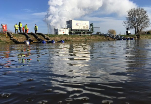
My main role in the recent flooding has been supervising our extensive pumping operation to empty the washlands as quickly and as safely as possible. It’s important to do this to create capacity in case of further rainfall. Creating capacity is vital, but so too is supporting local communities who have been affected by flooding and we’ve used additional pumps to reduce water levels and aid recovery.
It’s also really important that we have the right conditions to pump. If we pump water into the river when the tide is high, that just increases the level in the river. Pumping too quickly can also damage the embankments. That is why we have a pumping plan to ensure we pump at the best locations and times.
At the height of the recent flooding along the Lower Aire, we had 43 pumps pumping 13,000 litres every second. Whilst this number of pumps are able to pump around 19 Olympic swimming pools of water every hour, gravity is still the quickest, cheapest and lowest carbon way for the water levels to reduce, especially with the huge volumes involved.
We can never entirely eliminate the threat of flooding and there are situations where flood defences cannot cope with the levels of water we’re experiencing. It’s really important therefore that people sign up to our free flood warning service and have flood risk plans in place.
My colleagues and I live and work in Yorkshire and are committed and passionate about what we do and the importance of reducing flood risk. We’ve seen first-hand how devastating it can be. We’ll continue to work 24 hours a day doing all we can to prevent further flooding, supporting and working with local communities and partners and helping people recover.
Take care and please be #FloodAware
Adam Bayliss, Yorkshire Flood Manager at Environment Agency @AdamBaylissEA
7 comments
Comment by Huw Charlton posted on
Thanks Adam, most informative.
Huw
Comment by Keith Hughes posted on
Really good piece Adam. I live in Gargrave and there is a lot of debate about dredging, which apparently used to happen. What are your (and the EA’s) views on dredging?
Regards
Keith
Comment by Adam Bayliss posted on
Thanks Keith,
Sorry for the late reply, I seem to have missed these notifications.
Dredging is really common question, historically dredging was undertaken with little regard for environmental impact it had, spoils were removed which deposited on the banks and created large silt plumes.
There are some places where removal of silt or gravels serves a purpose i.e. where gravel has deposited under a bridge and is restricting capacity. However on larger tidally influenced systems dredging doesn't offer much, if any flood risk benefit, then there is the cost element. Dredging is incredibly expensive, most dredging spoil is contaminated waste when its tested and its a never ending cycle, with limited funding we have to spend the money in the best way that offers return on investment. I don't personally cover the Gargrave area so cant comment specifically on that locality.
And my personal opinion - I am very much an evidence based person. I personally live in an area at risk from flooding, but I wouldn't want dredging everywhere if it damaged the natural environment to the point where we didn't have fish, birds, invertibrates or greenery around it, especially if that dredging only had negligible benefit.
Hope that helps,
Adam
Comment by Dawn Whitehead posted on
We have evidence to the contrary, and you know that as I dealt direct with you over this recent flooding period. I look forward to the Section 19 "independent" assessment.
Comment by John Pearce posted on
I live in Snaith
What happen in Leeds?
John Pearce
Comment by Mr Duckett posted on
The River Aire washlands are designated as reservoirs and formal flood storage areas - https://flood-map-for-planning.service.gov.uk/confirm-location?easting=464260&northing=422273&placeOrPostcode=snaith and yet you are describing them as 'washlands'. Can you please explain how reservoirs and formal flood storage areas are actively manged and maintained by the Environment Agency ?
Comment by Emma posted on
Appears you may have an interesting point.
Can't wait to see their reply.