
The week before the 2000 floods, I was on standby duty. It had been a quiet weekend, but on Monday 30 October, the York AIR (Area Incident Room) was opened as soon as I got into the office.
We very quickly saw that this was going to be a big flood. We used our automated voice machine (AVM) to send messages directly to residents at risk of flooding. This had only recently come on line and replaced the previous warning system that involved faxing pre-written warnings to professional partners.
Our internal workforce was stretched and we asked for help from other EA departments and other areas who weren’t experiencing floods.
Pretty much all of our rivers were experiencing record breaking levels and as the peak came down the Swale, Ure and Nidd we saw flooding in the usual areas, including Ripon, Boroughbridge and Lower Dunsforth. Cawood and Selby were mostly spared but major flooding was seen in Barlby and our depot in Riccall was flooded.
On the Wharfe flooding was seen in Tadcaster, Ulleskelf and Ryther and the Derwent saw flooding in Malton and Stamford Bridge, just 12 months on from the 1999 floods in the same places. In the north of the area properties flooded at Stokesley, Croft, Neasham and Stockton.
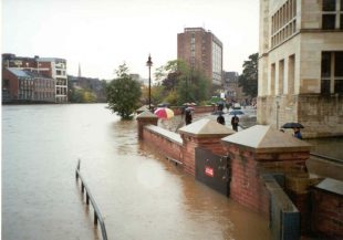
One of the main areas of concern was York where flood defences built after the 1982 floods were tested beyond their designed capacity at Water End, Lower Bootham, North Street and on the Foss.
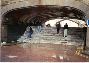
Due to the uncertainty in the forecast levels a decision was made to sandbag all the defences which made great photos for the media.
Hundreds of sandbags were laid against the Lendal bridge arch floodgate in an attempt to stem a small amount of seepage. It didn’t work. The sandbags were used by members of the public to climb up and see over the gate.
When the peak had passed and levels were falling, the weight of the sandbags began to push the twin doors of the floodgate open and almost flooded the area. We instructed the army to go back out and take all of the sandbags away.
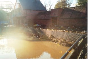
We also discovered a breach in the Clifton Ings bank. Staff from Riccall depot went slowly out along the flood bank with a dumper loaded with sandbags to plug the breach.
At the other end of Clifton Ings water had found its way across a field, around the end of the barrier bank, into Blue Beck and back into the Rawcliffe housing estate. Our staff used a bulldozer to try to fill the low ground but, working at night in difficult conditions, this wasn’t possible and around 80 properties flooded.
The Foss Barrier ran for a record 17 continuous days mostly using all eight pumps. There was also a real danger that water from the Ouse would flow over Tower Street and into the Foss Basin, effectively outflanking the Foss Barrier. Sandbags were redeployed to Tower Street and the army, who were still sandbagging at Leeman Road, were rushed there with a police escort.
Operation staff reported that it was like "desert storm" when a huge convoy of army lorries loaded with sandbags came across Skeldergate bridge and put themselves at the command of the Environment Agency site controller.
Staff were at Cawood, on the Ouse downstream of York, at midnight on Halloween and reported seeing lit pumpkins on top of the floodwall. As the washlands filled there were issues with water spilling out of Cawood and Wistow Ings, threatening to flood the village at high tide so the army were called in to build an emergency sandbag wall at the edge of the ings and major flooding was avoided.
Water overtopped a section of floodbank at Barlby to a depth of up to 300mm and in the region of 150 properties were flooded. Chinook helicopters were used for a massive deployment of sandbags to strengthen and raise the riverbank defences. More than 7,500 properties in Selby and Barlby were protected.
Just when we thought things were over water started to appear in the fields alongside the road between Bubwith and Howden, East Yorkshire, several miles from the River Derwent. An army Gazelle helicopter was used to fly over the flood water to help us identify that it was caused by a breach either side of a clough headwall. The Chinooks were called back for emergency works to airlift sandbags from Brieghton airfield so the army could use them to plug the gaps.
There was also serious concerns about a flood bank near Wressle that failed. Preparations were made to evacuate parts of Howden if we could not stop the floodwater as houses were built on the old course of the Derwent and the river was trying to reclaim its old riverbed.
The River Derwent in Malton and in Stamford Bridge peaked at a level higher than it did in 1999 which resulted in many properties flooding shortly after they had been renovated. Pumps and patrols were deployed to try to minimise the damage and disruption.
In summary, it was a very busy and stressful time for everybody involved. A 17-day flood at the time seemed like a long event but was actually much shorter than recent floods. We faced a huge demand for meetings with affected communities after the event - and many of these areas without defences are now much better protected.
So what has changed?
Nowadays we have many more people involved in managing flood events and make good use of modern technology.
We warn considerably more people that floods are on their way and the warnings themselves are more targeted and accurate, backed up with a wider reaching and more robust forecast service.
However, there is also a bigger expectation on us, both from the general public and politicians, and we work much more closely with our professional partners (local authorities, emergency services etc.).
But the nuts and bolts of what we do on the build-up to a flood and during a flood hasn’t changed as much as people might think. We still issue warnings and operate assets to help to reduce flood risk to the public. Everything that we do has evolved from past floods, sometimes in small steps and sometimes in larger leaps, but it has all been built on what those who came before us put into place.
Following the Boxing Day 2015 floods, £45 million of central government funding was provided for a York flood alleviation scheme. Construction work is ongoing on this. More than £30 million has also been invested in upgrading the Foss Barrier.
Check your flood risk, sign up to flood warnings and see advice on what to do in a flood at gov.uk.
Follow the Yorkshire and North East Twitter account.
Leave a comment