
Emma Formoy, Project Director of the Oxford Flood Alleviation Scheme:
After the summer we’ve just had, memories of Oxford’s roads underwater, the railway line closed, and water damage to homes and businesses may seem in the distant past. But working on the Oxford Flood Alleviation Scheme I’m aware how vulnerable Oxford remains to flooding. Climate change will cause large floods to become more frequent and severe, making the problem worse. So we build climate change projections into the design of flood defences to make sure they are fit for the future. The planning application for the scheme is currently being considered by Oxfordshire County Council and we’re hopeful for a final planning decision by the end of the year.
We’re pleased there’s a lot of interest in the project and naturally people are keen to know what it will mean for the local area. As with any scheme of this size there have also been some misconceptions and questions raised. So here I’d like to provide some of the facts behind our work and vision for the Oxford Flood Alleviation Scheme, to help answer some of these big questions.

Question: Why is such a big scheme needed?
Oxford has a long history of flooding. The floods of 2003, 2007 and 2013/2014 all wreaked havoc, cutting off parts of the city and causing devastation to homes and businesses. With climate change the impact of floods will increase and so any flood scheme needs to future-proof the city as best as possible, taking climate change into account.
After the floods of 2007, the Environment Agency considered over 100 different options to reduce flood risk in Oxford. Ranging from non-structural such as flood warnings, to maintenance including desilting and vegetation clearance, through to large engineering interventions like raised flood defences. We listened to advice from internal specialists, consultants, flood action groups and local residents. The results are set out in the Oxford Flood Risk Management Strategy, 2009.
Since then, the Environment Agency has managed the impact of flooding through the use of temporary defences and channel maintenance, which includes weed clearance, desilting blockage removal. But to help future-proof the city as best as possible, we need to reduce flood risk from the major floods we will start to see. The strategy found the scheme design that we’re taking forward to be the most effective and best value for money to achieve this.
The scheme we’ve designed enhances the existing floodplain to the west of Oxford, most of which is farmland and flood meadow. We will dig out material to create a natural looking stream which will always carry water, and a wider shallower area to the side of this, which will be planted with vegetation and will only carry water in times of higher flows. The majority of the material being excavated will be alluvium, a silty clay. We will reuse this material in the proposed flood embankments where we can. And excavated gravel will be re-used for environmental improvements and the new river bed. The “two-stage channel” makes more space for water to flow during flooding, whilst keeping the natural appearance of the area.
Due to the size of the area covered and work to incorporate the scheme with existing infrastructure such as major roads, railway line and utility supplies, the total cost is an estimated £121m.To deliver such an ambitious scheme we’re working together with 8 local partners, including councils, Oxford Flood Alliance and OxLEP (Oxfordshire Local Enterprise Partnership). This approach helped us secure a record £56 million in contributions from partners who support the scheme and want to see it progress. The remaining amount has been committed by central government.
Once in place the scheme will reduce flood risk to all properties in Oxford currently at risk of flooding from the River Thames. Homes and businesses are only part of the picture though. Two main roads into the city - the Botley and Abingdon roads - and the main railway line will also remain open in times of flood. This will benefit everyone who lives, works in, or visits the city, keeping Oxford open for business in times of flood. It’s estimated that for every £1 we spend on the scheme, the city will receive around £9 in benefit.

Question: Could you save money by simply dredging the current rivers?
Dredging on its own would never be the answer to protect Oxford from large floods. Even if we dredge all the watercourses in Oxford it would not provide the extra capacity needed in a major flood, and in fact it could be costly and damaging. We need to be very careful about where we dredge, as done in the wrong place it can be disruptive and damaging to the environment, and can increase flooding downstream. Rivers also tend to deposit more silt after dredging, making it inefficient and needing constant repeating. It would simply not be effective or sustainable in the way our scheme design is.
The Environment Agency currently has 2 maintenance teams covering Oxford who do a fantastic job to keep main rivers clear and maintain culverts and other structures. We only dredge where it’s cost effective and can be done with minimal impact on the environment and with no negative impact on flood risk downstream. This maintenance reduces flood risk from smaller, more regular floods, but it could never reduce flood risk from the size of major flood that the Oxford Flood Alleviation Scheme will.

Question: Will the scheme include huge motorway-style bridges that will impact the look of the area?
We’ve worked hard and listened to the views of the public to ensure that the new bridge designs are in keeping with the local environment. There will be new bridges where needed to keep access across the new two-stage channel. These will include a footbridge at North Hinksey and two larger bridges that can carry occasional maintenance vehicles at Willow Walk and the Devil’s Backbone.
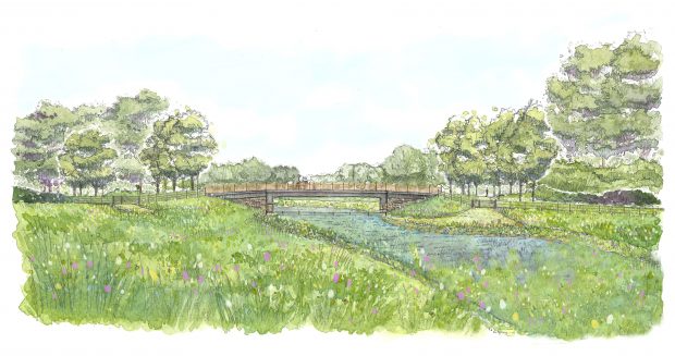
Willow Walk is an important historic route and well-used by pedestrians and cyclists into the city. The bridge we are putting in here is to replace the existing culverts and their metal railings. It’s not to replace the old stone bridge further down Willow Walk, which will remain as it is. The new bridge will continue from the existing track, just raised slightly higher, and will span 19 metres. It will provide more space for floodwater underneath and allow the path to cross the channel, which will be dry here most of the time. Unfortunately some Willow trees will need to be removed during construction of the new bridge, but once it’s complete we will be planting white willows to reinstate the avenue of trees on each side.
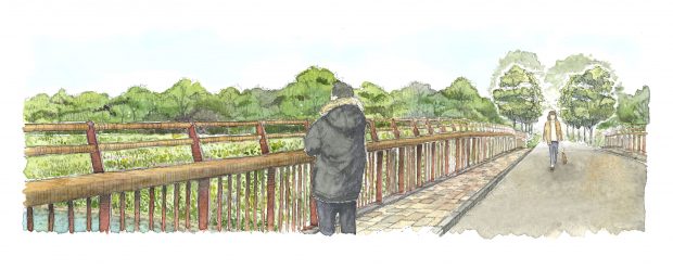
We listened to lots of people about the bridge design, including during our public consultation. We are going with the popular option of hardwood handrails and curved uprights in corten steel, which has a brown, rusted looking finish. The supports underneath the bridge will be clad with local stone. We hope that our illustration of how the bridge will look helps reassure people that we’ve taken their views on board and this is definitely no motorway bridge.
Question: Will the scheme damage the environment and reduce biodiversity?
We’re passionate about designing a scheme that will not only protect people and property from flooding, but will also deliver long term environmental benefits. The scheme will create over 15 hectares of new habitat and establish a wildlife corridor that links existing wildlife sites and improves biodiversity.
We know the construction phase will bring disruption and there will be unavoidable environmental impacts, which we’re working hard to minimise. We’ve conducted wildlife surveys over several years and made appropriate design changes wherever possible. We recognise the importance of Hinksey Meadows and have listened to Oxford Preservation Trust about this valuable wildflower-rich habitat. We adapted the route of the channel here as far as we can around the edge of the meadow, to avoid the main areas of rare flowers and grasses. We will also minimise changes in groundwater levels in the meadow by including gravel features, called riffles, in the channel downstream of Willow Walk.
Around 2 hectares of existing floodplain meadow will unavoidably need to be removed, but our plan is to create nearly 18 hectares of new floodplain meadow to help mitigate for this. We’re working with the Open University’s Floodplain Meadows Partnership to ensure we do this as sensitively as possible. Once the temporary disruption of the construction phase is over, the scheme will deliver a green legacy for everyone to enjoy, people and wildlife alike.
We will also need to remove areas of existing trees for the scheme but will plant around 10 hectares of native deciduous woodland in alternative locations within the scheme area. These will include species that are found locally, such as oak, alder, field maple, hawthorn, blackthorn and wild privet. The woodland areas will be managed for wildlife and include glades that are sown with wildflowers to encourage butterflies and other insects, as well as birds and foraging bats.
Question: Will the scheme be properly maintained in the long term?
There seem to be some misconceptions that after constructing the scheme we will just up and leave, with no thought for its future maintenance. This is definitely not the case. In fact, we are in a very strong position with the Oxford scheme and are already working on long term plans for the next 100 years. We have a team based in Osney who are out and about maintaining the watercourses around Oxford today, and they will continue their role by helping maintain the new scheme well into the future. We are also talking to local environmental groups about innovative ways they could help maintain the scheme habitat once it is in place, so that the area continues to see further environmental improvements in the long-term.
Author biography:
Emma Formoy has recently taken over as the Project Director of the Oxford Flood Alleviation Scheme. Emma has been a core member of the team since 2014, in which time she has been instrumental in securing the scheme funding, ensuring the scheme benefits the communities of Oxford and leaves a green legacy for years to come.

3 comments
Comment by Sa na posted on
When will this happen please?
Comment by eileenroffe posted on
Please send an information request to enquiries@environment-agency.gov.uk to receive full details.
Thanks, Joz
Comment by Sa na posted on
Thanks for your fast reply.
Im not looking for full details. I only want to know the Start/End date or month for this project.