
Sir James Bevan, Chief Executive at The Environment Agency
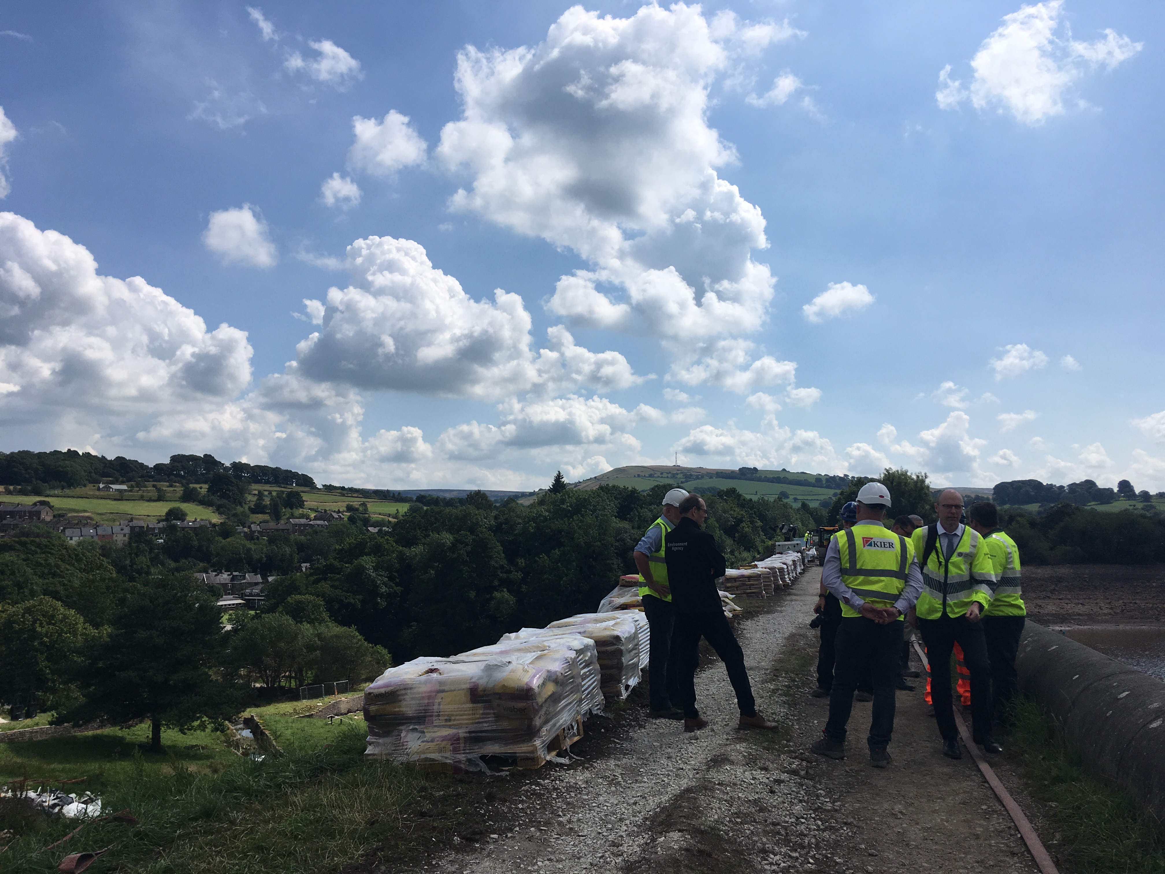
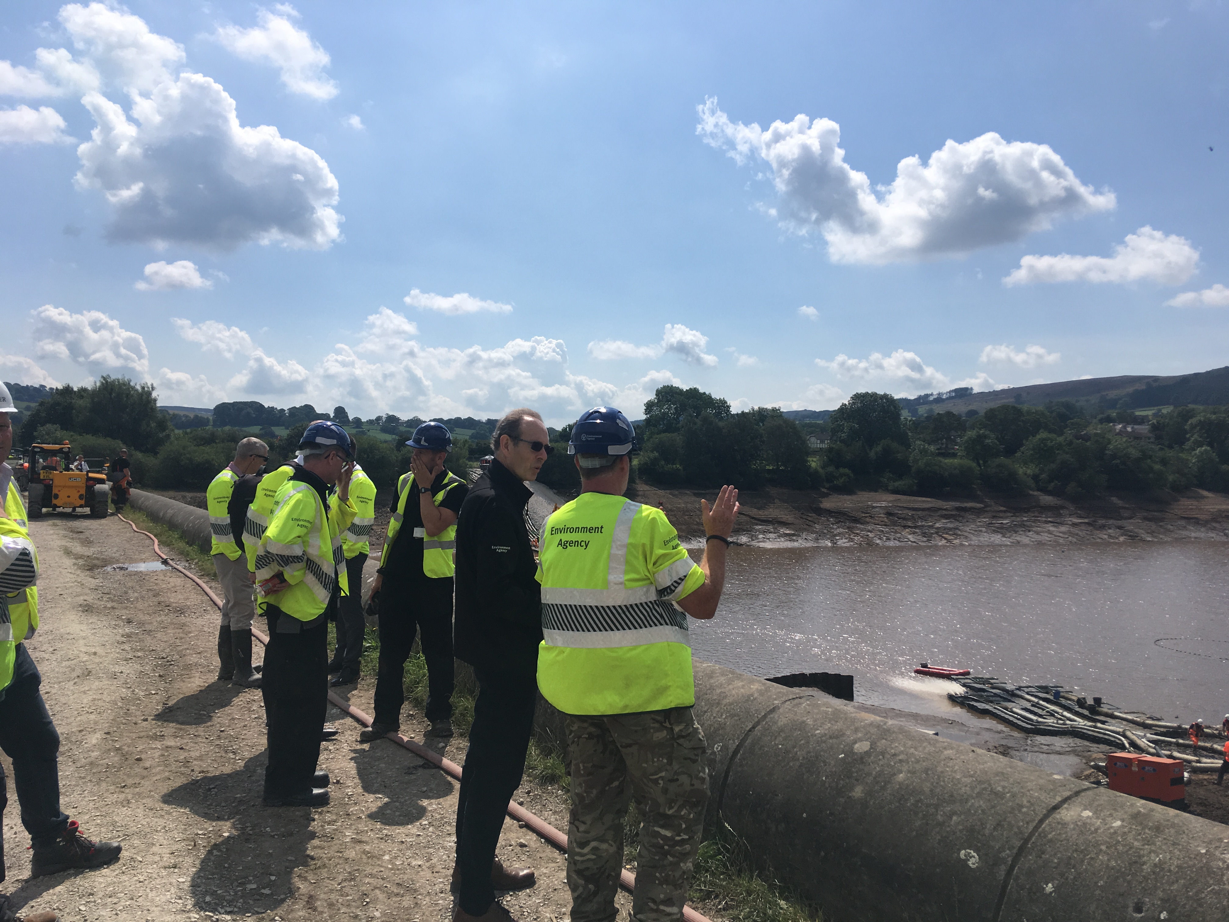
From the beginning of the Whaley Bridge incident, the Environment Agency has worked tirelessly with the emergency services and the reservoir’s operator, the Canal & River Trust (CRT), to protect the town. I was in Whaley Bridge today (8 August) to thank all involved and ensure we press on with the next stage of recovery and repair work.
We are delighted that the residents of Whaley Bridge are now able to return to their homes and businesses. This follows a thorough assessment of the stability of the dam and was the collective judgement of the police, emergency services, CRT and Environment Agency. It was made on the basis that water levels in the reservoir have decreased substantially and robust arrangements are now in place to ensure they remain low in the event of further heavy rainfall.
The reservoir has been weakened by heavy rainfall, and work is needed to restore the very high safety standards required by law. This will be carried out by the CRT under our supervision as the regulator.
Safety Record
Our reservoirs across England have an excellent safety record, with the last fatal failure being nearly 100 years ago.
Dams in England are regulated by the Reservoirs Act 1975, which sets out stringent conditions for the operation of reservoirs to ensure high levels of safety. They are designed and operated in a way to ensure the likelihood of failure is incredibly low.
Responsibility for ensuring the safety of reservoirs lies with their operators. Our job, as the regulator is to ensure they comply with the legal safety requirements. We monitor compliance at all 2,072 large raised reservoirs in England and employ a range of enforcement options to address non-compliance. These can include:
- Enforcement notices requiring reservoir owners and operators to complete outstanding safety works.
- Requiring operators to appoint Government-appointed supervising and inspecting engineers.
- Powers to force entry to conduct surveys, inspections and physical works.
- Direct intervention to carry out safety measures where an operator has not done so.
- Powers to force entry to land without giving notice and take any appropriate measures to reduce the risk or mitigate the effects of a failure. We have done this in the past.
Inspections and Enforcement
We routinely visit reservoirs across the country to assess risk, monitor progress and serve enforcement notices requiring operators to complete specific actions. Our absolute focus is to maintain the safety of these reservoirs and we will not hesitate to prosecute operators if they fail to take action and cause a threat to life. We recently used these powers to carry out safety work at five reservoirs where the risk was deemed to be unacceptable.
Reservoirs with the capacity to threaten human life in the event of a failure are designated Category A and subject to the most stringent inspection and supervision requirements. All Category A reservoirs are monitored by a supervising engineer who reports every year on any potential safety issues and are subject to a statutory inspection every 10 years. The Toddbrook Reservoir at Whaley Bridge is a Category A reservoir.
When a reservoir is inspected the engineer will recommend the action that needs to be taken to ensure its safety and the deadline by which this action must be taken. The recommended actions and the deadline are the responsibility of the operator, not the Environment Agency. Those recommendations may include measures to be taken in the interests of safety (MIOS). Having a MIOS does not mean the reservoir is unsafe and does not indicate an immediate threat to life. There is no reason to assume that there is a heightened risk of a dam failure at any reservoir with outstanding MIOS.
MIOS indicate that a robust inspection and supervision process has identified something of potential concern by an expert civil engineer, who sets an enforceable deadline for it to be addressed by the reservoir operator. MIOS can include administrative requirements such as the preparation of an on-site safety plan. We regularly assess all reservoirs with overdue MIOS and take appropriate enforcement action.
Currently there are 15 reservoirs out of 2,072 across England that are Category A and have overdue MIOS.
Every reservoir with an overdue MIOS has an Environment Agency enforcement officer actively using our powers to manage the operator. To be clear, we will not allow a reservoir to continue to operate if we believe it poses a danger to the public.
So far, we have prosecuted two reservoirs and have used our legal powers to step-in and carry out physical works ourselves at five reservoirs where a risk was unacceptable.
Infrastructure
Following the partial collapse of the dam slipway at Whaley Bridge, we have contacted the operators of all large reservoirs asking them to check that their reservoirs have not suffered any damage after the recent heavy rainfall. We will also be checking all the reservoirs that we own and operate ourselves.
Events at Whaley Bridge demonstrate how reliant many parts of our lives are to the impacts of the weather, demonstrating how crucial it is for all infrastructure to be fit for the future. We recently consulted on a draft strategy for the nation’s flood risk, which considers the challenges of today’s infrastructure in a changing climate.
The main focus of our work in flood and coastal risk management has always been public safety - none more so than with our nation’s reservoirs. We will continue to work with reservoir operators and engineers to maintain this country’s leading safety record.
I personally would like to thank all of our hugely dedicated staff, as well as the emergency services and military personnel, who through their swift and decisive action saved the homes and lives of Whaley Bridge’s residents.
7 comments
Comment by Michael Mann posted on
I was close to the WB incident and several things seemed pertinent and question the veracity of the inspections and the reliance upon the operators to take action (which they didn't):
1. the spillway slabs were not tied together or reinforced in any way and the joints were left open and were not maintained - as evidenced by the weeds and shrubs growing in the joints (similar to many of our older bridges).
2. The spillway was restricted by the angled side wall and this acted like a venturi and concentrated flow into the area of failure.
3. the stepped foundations to the side wall were shallow and not resistant to undermining.
4. it appeared that the dam did not 'fail' as widely stated, but the spillway slab joints were eroded by the high pressures and volumes of run-off. This eroded the joints, allowed the slabs and side wall to be undermined, and exposed the dam to risk of failure if the flow continued. Thankfully it didn't.
5. The evacuation and engineering measures taken were appropriate and effective.
6. The alarmist statements by police did not help and have created a sense of fear amongst some residents that the dam is somehow unsafe. The 'you are going to die' (literally) statements by police will not leave peoples minds quickly. It would have been better to be firm (get out) but calming (this is precautionary. there is high risk but we hope that things are not as bad as they might seem). An early statement of reassurance about the damage that occurred, the fundamental suitability of the structure, and what will be done to repair and improve the dam so that this can 'never' happen again would help everybody. Consultation should be part of any programme of inspection and repair/improvement so that people can be reassured.
7. the police should consider who is best positioned to lead and advise in such situations. The assistant CC appeared 'flaky' and whilst appearances may not be the best selection criteria a sober-suited engineer might have been the best person to make statements on engineering matters and facts, not a legal person, to provide reassurance and calm facts.
8. 7 days of support is not sufficient after such an event. Several people left the town and have been staying away or on holiday - what do they do when they return? How will children and parents be reassured that they are safe? They have the impression that catastrophic failure could occur at any time and the Merthr Tydfil disaster has been referred to as 'similar'.
Comment by Siv Ananda posted on
Excerpt from https://www.bbc.com/news/uk-england-derbyshire-49220650
'No cause for concern'
Rachel Pether is a dam engineer who carries out safety inspections of reservoirs.
"As an All Reservoirs Panel Engineer I would say that there is nothing in the photos that would cause me concern, and nothing that would indicate that the dam is not being maintained properly in general," she said.
Interesting observation. Rather difficult to be so emphatic.
Comment by Siv Ananda posted on
Here are some observations based on the gleanings of media reporting (written and audio/video) , Wikipedia feature on the dam, and other publicly available data.
First, were the regular inspections only structural and confined to surface and visual observations? Was the hydraulic effects on structural elements of the emergency spillway such as concrete facing thickness, joint details etc reviewed, especially after lessons learnt from the Oroville spillways failure in the USA? Chances are that old design drawings may not be available for the inspecting engineer, but NDT (non-destructive testing) geophysical instruments are available to measure concrete slab thickness while also detecting any voids below the slab. The slab thickness appears to be not thick enough to counter uplift during high flows and there may have been undetected voids below the slab that were also contributory to the failure.
Second, spillways have become the Achilles heel of dams. This is not just due to erratic meteorological/hydrological conditions in more recent years as surmised by some observers and effects of aging on concrete etc but also on an often "unseen hand". That is sedimentation of the reservoir.
The reservoir filling up up very quickly because it has steep-sided hills on either side may at least partially be the result of heavy sedimentation accumulated behind the dam over several decades. If there is much reduced live storage capacity left due to high siltation, the reservoir can fill up rather quickly. Was there hydrographic survey done by the inspecting engineers? Was any dredging ever done?
Third, it appears from photos that the geometry of the spillway layout is asymmetric. The north wall of the spillway is not parallel to the south wall. Uneven hydraulic forces can also be at play. The narrowing of the spillway chute forming a triangular wedge from the top to bottom and the damage being confined to this triangle is telling. If it is hydraulic in origin, it can be due to unsteady flow due to constriction where the rest of the spillway has uniform flow. This is evident in photos.
Fourth, the dam is 188 years old, has a clay core flanked by earth with concrete slab protection on the downstream side. From the photos, the slab does not appear to be thick enough. Notwithstanding that, it is not only not reinforced with steel, it has no keying that can help against water getting under the slabs.
Fifth, the buttressing effect of the clay core & earth flanks against the abutting wall/bulkhead can be causing local distress. The failure section appears to be located in the deepest section of the dam where the new spillway was built in 1969. As this auxiliary spillway was constructed later as a modification, both design as well as construction can bear on the incident. The erosion gulley seen along the other side of the wall in the upper area of the failed slabs may be also be a source to examine and see how and when this developed. Was this there during the November 2018 inspection?
Vegetation seen on the reservoir side of the spillway is also not a helpful thing. Many photos show uncommon growth. One estimated as 1 meter (3 ft) high can be seen as bearing the onslaught of the high velocity flow. However this may not have been the major contributory factor in this failure.
From Wikipedia:
............Investigations in the late-20th century led to doubt as to whether the dam was constructed as laid out on original drawings – with a puddle clay core and embankments of more porous material on either side – or with more porous core material. ............In 1977 it was noted that there had been 12 centimetres (4.7 in) of subsidence since 1975. Are these corroborated? If so, there must have been even higher settlement between the year of construction (1969) and 1975 also. What caused the settlement and its impact are topics worth exploring.
The 2019 Google Earth aerial shows a hole about 1mX1m (about 3ftX3ft) in the northernmost horizontal slab at the crest of the spillway. This shot must have been taken after the November 2018 inspection and before the incident. From the shadow in the imagery one can see earth below. It is hard to see how deep it is. Was this found in the November 2018 inspection? Can this point to something here?
Also, cutting off seepage paths is a critical requirement in hydraulic structures, especially embankment dams. When the auxiliary spillway was built in 1969, what was its impact on the puddled clay core? I can only estimate that it would have been cut into when building the north abutment wall of the spillway.
Especially under high reservoir levels, unless the wall was built with say, vertical ribs and wide enough footings to lengthen the seepage path, the seepage flow net may have high hydraulic gradients resulting in migration of fines and eventual piping.
It appears that piping and the resulting uplift pressures under the slabs in the upper portion of the tapered north wall area is a distinct possibility to explore. Whether the eroded gully on the other side of the failed slabs preceded or followed the slabs failure is dependent on analyzing seepage paths. The slabs in the lower parts are relatively stable. Why the focus on the northern corner.
Comment by eileenroffe posted on
Good Morning - I have forwarded your request to the area customer and engagement team for their response - Eileen
Comment by Dr Drew Campbell posted on
I am currently researching the history of the uk’s reservoirs. Where can access a complete list of the 2072 reservoirs?
Comment by eileenroffe posted on
Good afternoon, please email into us at: enquiries@environment-agency.gov.uk - we will then forward your request to our national requests team to compile the report. Please note information requests as per our customer charter allows 20 working days. Thank you - Eileen
Comment by Judy Woods posted on
Why would you put 173 Homes within 10 m of a Class A High Risk Earth Embanked end of life Impounding Reservoir built 1855, containing 91,000 m3 of water and 19 mine shafts to its frontage. Cant get any worse ? Well the only significant watercourse capable of Draw Down either Emergency or Testing ( Last tested 30-40 yrs ago) as per the SUPe informative is both Blocked and demised . So in the event of the SoS 2021 Directive to have an effective On Site Emergency Plan , and its no secret the first ingredient is Draw Down . So , Where will 91,000 m3 of water go in the necessity of an Emergency Draw Down , You need to have a word with your Reservoir Compliance Team on Park Dam Low Moor Bradford