
As a Hydrometry & Telemetry Technical Specialist it’s my job to provide my colleagues and our partner organisations with technical information on surface water, rainfall and groundwater.
For the past year or so I’ve been working on the Midlands Fish Pass Project which aims to improve fish and eel migration along rivers and streams by providing safe passage for the fish at hydrometric gauging weirs. These are the weirs we use to collect important water data. I often find myself making tough choices between our ability to collect accurate hydrometric data, and improving the ecology within our rivers. It’s a fine balance to achieve both!
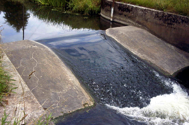
One of the locations that I have worked on is the Rodington Gauging Station, one of 12 weirs being modified as part of the project. The River Roden is classed as a failing water body due to numerous barriers to fish along the river, the largest of which is the gauging weir near the village of Rodington in Shropshire.
All fish migrate, not just the well known ones like salmon. They do this for one of three reasons, to reproduce, to find food or avoid predation. Unseen to most people the river is a fish highway throughout the year. Barriers to migration, like gauging weirs effectively cut up the river into sections. The impact these barriers have was poorly understood when they were first built. Thankfully now we are far more knowledgeable on fish behaviour. This knowledge enables us to improve passage for all fish species, in turn this benefits the wildlife that depends on them.
One species that provides particular challenges is the eel. By the time an eel reaches the gauging station at Rodington it has already traveled several thousands of miles from its birth place in the Caribbean. Despite this lengthy migration, eels are poor swimmers; they use tidal currents, areas of slack water and will even travel over land to migrate upstream. Gauging weirs pose a particular problem as they are made to channel the flow to allow accurate measurement. This channeling removes the areas of slack water and increases flow velocity. They can act as a total barrier to eel migration and don’t forget 10 years later the eels perform the whole migration in reverse back to the Caribbean, quite a life! To allow eels to migrate they need a specific pass built around the weir, which takes very little water and has a rough floor of bristles which allows the eels to crawl upstream almost out of water.
By monitoring the water level upstream, we calculate very accurate flow information, which is logged every 15 minutes. Data from the gauge at Rodington is used for:
- Community based flood warnings
- Flood forecasting
- River regulation and drought monitoring
The information supplied by the gauge showed us that we needed to make some changes to the main weir to make it possible for fish to pass during high as well as low river levels. We did this by installing a Larinier fish pass, which uses a set of plates or “baffles” set within a concrete channel. The baffles slow the water down and create water conditions which make it easier for fish to pass, whilst providing a stable hydraulic control which can be used to accurately derive the river flows.
Larinier passes are usually installed in by-pass channels around the weir, however at Rodington we chose to modify the existing weir with an in-channel Larinier. This substantially reduced construction costs while enabling fish to pass freely.
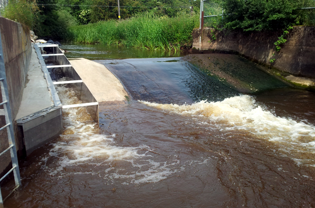
The picture above shows the completed Larinier fish pass and to the left encased in metal the eel pass.
We will closely monitor the gauge to ensure that the flow data that we record is still accurate. Fish populations upstream of the gauge will also be monitored in coming years to assess the effectiveness of the fish pass. This is another big step towards improving our environment and making it a better place.
Leave a comment