
For the past 17 years we have been capturing LIDAR (Light Detection & Ranging) data in England. LIDAR uses a laser to scan and map the landscape from above and is widely considered to be the best method for collecting very dense and accurate elevation data across the landscape.
We use LIDAR to help the work of the Environment Agency in many ways, including creating flood models, assessing coastal change and analysing how land is used.
 We now have an extensive archive of aerial LIDAR data covering nearly three quarters (72%) of England – the data mainly covers flood plains, coastal zones and urban areas. As technology has improved and costs have fallen, LIDAR data is now being used by just about everybody who works with maps. From local planners to archaeologists, farmers to ecologists, LIDAR data can inform their work.
In 2013, we made the data available for free for the first time for non-commercial use to anybody who wanted it. In that time more than one million km2 of data has been downloaded.
Following the Winter Floods 2014, we committed to ensuring our information is available, by publishing as much of it as possible as Open Data – free of charge and restrictions. From September 2015 all our LIDAR data will become Open Data and everyone will be able to use it for free.
 We are releasing two LIDAR products under the Open Government Licence and you will be able to access these through Datashare.
- Tiled LIDAR data
The full tiled dataset consists of historic LIDAR data which has been gathered since 1998. For some areas we have carried out repeat surveys and data is available in a range of resolutions. - Composite LIDAR data
The composite dataset is derived from a combination of our full tiled dataset which has been merged and re-sampled to give the best possible spatial coverage.
By making the LIDAR data open to all, users will be able to access it free of charge, even for commercial use. We hope that by removing any cost barriers, our data will improve the quality of flood risk modelling used by businesses and local communities and allow for the development of innovative tools and techniques to further benefit the environment.
Dr Alison Matthew is Geomatics Manager at the Environment Agency. She has over 25 years experience working in operational remote sensing.
84 comments
Comment by Matt posted on
A good step forward in sharing content to everyone and driving development.
Comment by Alex posted on
Excellent news! Will both the surface and terrain models be made available?
Comment by Environment Agency posted on
Good Morning Alex, Yes, both DSM and DTM will be available as Open Data. For more information please visit our web portal at http://www.geomatics-group.co.uk.uk. Eileen
Comment by Tom posted on
Thanks Eileen. The geomatics portal link isn't quite right. I think you meant http://www.geomatics-group.co.uk.
Comment by Jon Chandler posted on
This sounds fantastic.
Will the data include Bathymetry LiDAR data? (water penetrating - ie channel bed)
Jon
Comment by Environment Agency posted on
Hi Jon
We have passed your question to the author of the article and will reply once we hear back from them
Regards, Jayne
Comment by Environment Agency posted on
Hi Jon
Thank you for your interest. We would advise that the Environment Agency doesn’t hold any Bathymetric LIDAR data
Regards, Jayne
Comment by Simon posted on
Is it only English data that's being released?
If so- why? And when might data for the rest of the UK be made available?
Comment by daveferguson posted on
Hi, The Environment Agency will be providing LIDAR data for England. For Welsh LIDAR data the custodians are Natural Resources Wales (NRW) – please contact them, thanks
Comment by Andy Ketley posted on
Wonderful news!
You are setting the bar high for others to follow. Let us hope they accept the challenge. Free technology is the way to engage and motivate the smaller organisations among us.
Thanks,
Andy
Comment by daveferguson posted on
Thank you
Comment by Phil Lewis posted on
Hi, in the email I just received about this excellent news and also above, am I correct to assume that this free availability is for England only and that other parts of the UK are excluded?
Comment by daveferguson posted on
Hi, The Environment Agency will be providing LIDAR data for England. For Welsh LIDAR data the custodians are Natural Resources Wales (NRW) – please contact them, thanks
Comment by Peter posted on
Is the data going to be available for commercial use? If so will it be free of charge?
Thanks
Peter
Comment by daveferguson posted on
Yes – the data is going to be freely available for commercial use
Comment by Caroline posted on
This is fantastic news. For amateur archaeological groups this Lidar is proving invaluable and now being free will hopefully encourage other groups
Comment by daveferguson posted on
Thanks - great to hear of its use for archaeology!
Comment by Joe Rigby posted on
Will it be possible to develop obj mesh files and textures from the data
Comment by daveferguson posted on
Good Afternoon, You will be able to develop object mesh files and textures from the data if you have the appropriate software. Eileen
Comment by Pan posted on
Will the ASCII files ,DTM + DSM be available please.?
Comment by daveferguson posted on
Hi, 2. Yes – ASCII files, DTM and DSM will be available, thanks
Comment by andy seaman posted on
Hello,
Will data be available for Wales as well?
Comment by daveferguson posted on
Hi, The Environment Agency will be providing LIDAR data for England. For Welsh LIDAR data the custodians are Natural Resources Wales (NRW) – please contact them, thanks
Comment by daveferguson posted on
Hi Wales have their own team. Please contact them at: https://naturalresources.wales/splash?orig=/ Thanks in advance - Eileen
Comment by robert murphy posted on
This is great news.
Thanks so much for helping the government to increase UK productivity in the wider economy.
Comment by Abhi posted on
Is LiDAR data available on datashare?
Comment by daveferguson posted on
Good morning, please find the link to datashare and what information is available: http://www.geostore.com/environment-agency/WebStore?xml=environment-agency/xml/index_public.xml and here is the link for the geomatic website: https://www.geomatics-group.co.uk/geocms/ ^Eileen
Comment by Rob posted on
Hi, I'm trying to find the right files to download to use in MapInfo - which datasets should I choose? Everything I go for seems to be line data. Thanks.
Comment by daveferguson posted on
Good morning, what is Mapinfo please thanks in advance. ^Eileen
Comment by Steve Malone posted on
Exciting news, and I look forward to making use of it. When it arrives! As of 13.30GMT today there's still no sign of anything on Datashare, Geomatics or anywhere in data.gov.uk to point towards any actual open data.
Comment by Gijs Nijholt posted on
Please release the raw LiDAR pointcloud as well. The Dutch govt did that and it's led to a couple of great projects and products by 3rd parties already.
thx
Comment by daveferguson posted on
Hi, LIDAR Point Cloud data will be released as open data and will be available by June 2016
Comment by Chris Little posted on
Encouraging news. Were you aware that in a couple of weeks (14-17 Sept 2015), a new standards working group is being convened at the Open Geospatial Consortium Technical Conference, held at BGS HQ in Keyworth, Nottinghamshire?
One intent is to agree global interoperability standard(s) for Lidar data in conjunction with ASPRS [http://www.asprs.org ]. See [http://www.opengeospatial.org/projects/groups/pointclouddwg ]. Interested parties can join the e-mail list at: [lists.opengeospatial.org/mailman/listinfo/pointcloud.dwg ] .
I think there should be more representation from the Open Data community.
Comment by daveferguson posted on
Hi, Many thanks for the information. Unfortunately we are not able to attend on these particular dates, however we look forward with interest to reading about the outcomes of the meeting
Comment by john malley posted on
Is there a 'backdrop' map available to id the specific map tiles required once you open the portal ... currently it is just a set of blank grids. With the old site you could id the area geographically - now it just appears to be by postcode
Comment by daveferguson posted on
Hi, thanks for contacting us. For help with your query please contact ea-support@infoterra-global.com or 0800 912 1288
Comment by Ian posted on
Still no sign of a working site. Any news on what is going on and an etc when the service will be up and running?
Comment by daveferguson posted on
Hi Ian, Sorry to hear you are having difficulties accessing the site. Would you be able to tell us the URL address of the site that you are trying to access so we can see how we can help further. Both the Datashare http://www.geostore.com/environment-agency/WebStore?xml=environment-agency/xml/index_public.xml and the geomatic website https://www.geomatics-group.co.uk/geocms/ seem to be working OK.
Comment by Ian posted on
http://www.geostore.com/environment-agency/survey.html
http://environment.data.gov.uk/ds/survey#/
Both of these pages don't work for me, I get nothing showing up no map interface. The odd thing is it works on my iPhone, but I cannot download anything.
Comment by daveferguson posted on
Hello Ian, Sorry that you are still experiencing difficulties with these sites. For technical queries regarding the Datashare portal, please contact ea-support@infoterra-global.com or 0800 912 1288, Many thanks
Comment by Bharadwaj posted on
Hi, is there any index file , extent file and source date file for "Composite LIDAR dataset"? I feel very difficult without having any such information. Is there any option for bulk download (Like
FTP server path)?
Comment by lisa posted on
The terms and conditions say we can't use this for commercial purposes. Is this correct?
Regards,
Lisa
Comment by daveferguson posted on
Hi Lisa, LIDAR data is now open data and available under the Open Government Licence http://www.nationalarchives.gov.uk/doc/open-government-licence/version/3/. This means it is free of charge and restriction, including for commercial use. The Terms & Conditions on the Datashare web portal have now been amended. Eileen
Comment by stephen Gibson posted on
Having data freely provided is great, however the other element is being able to see and use it on a productive basis for small flood evaluation projects, down to a single house domestic use.
To afford maximum advantage both to the public and small businesses who cannot afford the expensive flood modelling programmes, is there advice on compatibility with the main international free open source GIS programmes - such as Mapwindow?
A problem is you cannot limit the area wanted to a single grid section, instead you get 100MB of an entire area such as SP20. Is the idea that you the delete the sections outside the area interested manually or am I missing something?
Comment by daveferguson posted on
Hi Stephen, For more information on our LIDAR data and how to use it, please download the FAQ, which can be found on the LIDAR download page at http://environment.data.gov.uk/ds/survey#/download
Comment by Bob Garlant posted on
Great news for amateur archaeology groups such as the one I belong to. Is there any particular software program needed to open and view downloaded files please?
Comment by daveferguson posted on
Hi Bob, For more information on our LIDAR data and how to open it, please download the FAQ, which can be found on the LIDAR download page at http://environment.data.gov.uk/ds/survey#/download
Comment by Cain Hegarty posted on
Hi, to echo Bharadwaj;s comment above, its there any document or file available that would give an indication of coverage extent?
Best,
Cain
Comment by daveferguson posted on
Good Morning Cain, A shapefile showing the coverage extent for each resolution of composite LIDAR data can be found on data.gov.uk . These can be found as a link on the second Resource Locator. Cheers. ^Eileen
Comment by Heather posted on
Hi,
Can the ASC Files be opened in AutoCAD 2015 (not Civils 3D). Or will they have to be converted first? I can't seem to find a way to view/import/open or convert them using CAD. Thanks.
Comment by daveferguson posted on
Hello Heather, For more information on our LIDAR data and how to open it, please download the FAQ, which can be found on the LIDAR download page at http://environment.data.gov.uk/ds/survey#/download
Comment by Alessandro posted on
hello Heater,
I am experiencing the same problem, trying to import lidar data into AutoCAD Map 3d 2016 though the Re Cap 2016. I couldn't find the answer in the FAQ. Have you solved the problem?
Thanks
Comment by daveferguson posted on
Hello, Sorry that you are experiencing difficulties with the data site and that you couldn't find an answer in the FAQ. For technical queries regarding the Datashare portal, please contact ea-support@infoterra-global.com or 0800 912 1288, Many thanks
Comment by Jurgen posted on
Which geoid model (height reference) has been used for the LIDAR data ?
Comment by daveferguson posted on
All our data is OSGB'36 British National Grid, with elevations recorded Above Ordnance Datum Newlyn (AODN). For more information please download the FAQ, which can be found on the LIDAR download page at http://environment.data.gov.uk/ds/survey#/download
Comment by Paul Evans posted on
Hi there, is there any way of acquiring the metadata associated with the LiDAR data, i.e. what time it was flown, the vertical accuracy, etc.
Thanks, Paul
Comment by daveferguson posted on
Good morning, Meta data for all of our LIDAR data can be found on data.gov.uk. ^Eileenhttps://environmentagency.blog.gov.uk/wp-admin/edit-comments.php?comment_status=approved#comments-form
Comment by Richard Summers posted on
Hello. Are you able to say when the datashare website will be up and running?
Comment by daveferguson posted on
Hi Richard, Apologies but the Datashare website was temporarily down due to essential maintenance. It is now available again. You can access it through the link in the blog above
Comment by Rafal posted on
Hello, is there similar data for Scotland also available ?
Comment by daveferguson posted on
Hello Rafal
Try contacting Scottish Environment Protection Agency (SEPA) http://www.sepa.org.uk/
Comment by Imran Hamblin posted on
Hi
I have downloaded all the DSM and DTM files that was available (thanks you very much). However I'm having trouble bringing them into ArcMap 10.2.2. The tiles dont seem to be georeference and end up in the complete wrong place. I'm fairly new to ArcMap so I'm probably doing something wrong. Any advice/help would be very much appreciated
Comment by daveferguson posted on
Sorry to hear that you are experiencing difficulties with files. For technical queries regarding the Datashare portal, please contact ea-support@infoterra-global.com or 0800 912 1288, Many thanks
Comment by John Aldridge posted on
This data is fun to play with - thank you! Are you likely to be filling in the gaps where there is, at present, no data? If so, is there a schedule or plan for this?
Comment by daveferguson posted on
Hi, thanks for contacting us. The Environment Agency operates an annual National Programme of LIDAR data capture which is used for, amongst other things flood mapping and environmental monitoring. The locations we survey are determined by the local needs and priorities for Flood and Coastal Risk Management, based upon where the greatest need is for up to date topographical data in any given year. These requirements are constantly being updated, therefore we are unable to publish a plan of future surveys. Hope this helps
Comment by John Aldridge posted on
I thought that might be the case! Thanks anyway for taking the time to reply.
Comment by Vivek Vaibhav posted on
Hi
Is there a way to know when the Lidar data was updated, or when the survey was done?
Thanks
Comment by daveferguson posted on
To find out the date the LIDAR survey was flown click on the ? next to the dataset you downloaded from http://environment.data.gov.uk/ds/survey#/download. Then select the second “resource locator”, from where you can download a shapefile containing that information.
Comment by Lara Band posted on
It's great that this is now open data. I can view the data at work as we have ArcGIS but wish to advise the amateur archaeology groups I work with how they can view the data if they don’t have GIS software. So: is Flickr the ONLY way to view the data if you don't have specialist software?
I've seen the answer above "For more information on our LIDAR data and how to open it, please download the FAQ, which can be found on the LIDAR download page at http://environment.data.gov.uk/ds/survey#/download" and have read this document but would just like verification.
Thanks
Comment by daveferguson posted on
Hi, the page you mention should include a link to a list of open source GIS tools that you may find helpful http://environment.data.gov.uk/ds/survey#/download.
Comment by Stephen Ransby posted on
What reason did you have for the low-flying aircraft over The Holme Valley in West Yorkshire last night?
Comment by daveferguson posted on
As the Environment Agency’s remote sensing team it is our job to capture aerial survey data of England, which is used for flood risk mapping. Every year we survey thousands of square kilometres of England using LIDAR to produce detailed digital height models. The locations we survey are chosen based upon which areas are most at risk or where the greatest need is for up to date topographical data. Unfortunately due to operational constraints, many of our aerial surveys have to be conducted from an altitude of approximately 2,500ft above ground level and often at night. The altitude is much lower than a passenger jet, but is not as low as typical police or military flying.
Comment by Alex posted on
Amazing work! That is the right way. Congratulations! Thank you
Comment by Tom Perks posted on
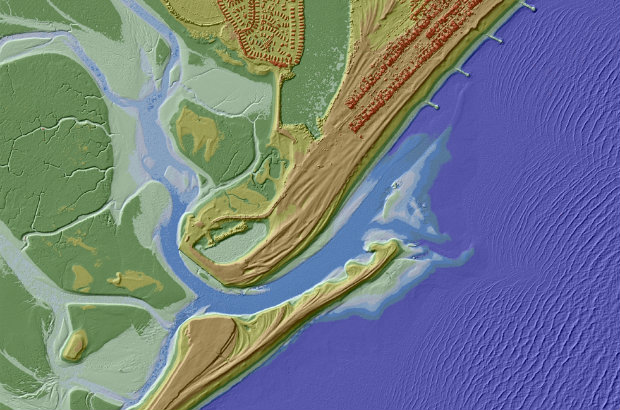
The DEM of Pagham spit at the top of this page looks really cool - is it based entirely on LiDAR data? Or was multibeam data used for the offshore area? Also I really like the 3D effect - was this achieved using hillshade effects? Thanks
Comment by Laurence Harrison posted on
Unfortunately after some extensive testing downloading a series of grids in order to produce a pointcloud I have found that the tile that is expected doesn't arrive, Instead I am getting files that are of a totally separate location. I have tried to download the TQ37 grid (which is shown over the Farringdon area). However once processed the Crystal palace park appears. I would of assumed that grid coding would correspond with OS grid system but they are entirely different to the grids shown the ordnance survey. Could you get someone to contact me in order to get the bottom of these issues?
Comment by kathrynbooth posted on
We have been experiencing some problems with the download site in the last few days, it should be fixed now.
Please let us know if you continue to have problems by contacting our technical support team on ea-support@infoterra-global.com
Comment by Keith Allen posted on
I seem to have found a discrepancy between LIDAR data and the OS spot heights. At East 331053 North 431900 there is an OS spot level on a carriageway centreline of 7.6. The LIDAR data gives levels in excess of 8.5m for some distance in any direction. Nearby levels in OS and old OS shhets seem to bear out that 7.6 is in the right ballpark.
Has the wrong file downloaded please? The file is SD3131_DTM_2M.ASC. I have checked against spot heights nearby in the same 1k square and have found other discrepancies - suggesting the wrong file? I am using a small in-house program specifically written to extract values for a small area to a csv file and have not had any problem at all in the past.
Comment by Susan Winter posted on
Hi Keith, Please can you contact us directly at geomatics_data@environment-agency.gov.uk. We require more information from you in order to be able to look into this discrepancy.
Comment by Julian Todd posted on
Hi,
Have you got a policy explaining which parts of the UK you are choosing to overfly and scan.
Is there any chance it could extend a few metres up the slopes of the valleys to the caving/karst regions of North Yorkshire and the Mendips (Somerset) where all the cave entrances are found?
We are relating the few Lidar scans where they have strayed into the right areas (such as on Fountains Fell north of Settle), but it would be awfully nice if it could take in the rest of the important areas.
You probably don't take requests, but caves are arguably hydrological features where the water is flowing in tunnels instead of visible river valleys. We could do something about filling you in with data on the known main drains that could be included in the flood models.
We are in the process of relating our detailed cave surveys of the biggest systems (now online here http://cave-registry.org.uk/ ) having just discovered these lidars and QGIS, so it's interesting times.
Comment by kathrynbooth posted on
Good Morning, please email in to us at: enquiries@environment-agency.gov.uk. We will then pass to the team. Eileen
Comment by Sophie posted on
Why does the link to "Datashare" say it'll be back up and running in August 2017? It's March 2019.
Comment by DANIEL BERRIMAN posted on
Hello, I note from the thread above there is reference to the release of the Point Cloud data a while back; did this ever happen?
Comment by
daveferguson
posted on
on 10 September 2015
Hi, LIDAR Point Cloud data will be released as open data and will be available by June 2016
many thanks
Comment by manual handling training pdf posted on
I am so grateful for your blog. Really looking forward to read more. Much obliged.
Comment by Anthony Woodard posted on
no links worked and access to data seems to be hidden